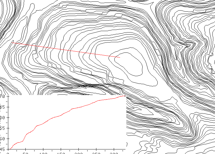
If the contours represent the landscape accurately, our results are useful. If not, it may be necessary to smooth the DEM so that slopes will be more accurate. The slope map below shows how sensitive slopes are to the spacing of the contours.
The contours are not evenly spaced. (See the map and profile below.)
If the contours represent the landscape accurately, our results are useful.
If not, it may be necessary to smooth the DEM so that slopes will be
more accurate. The slope map below shows how sensitive slopes are to
the spacing of the contours.
setenv GRIDALLOCSIZE 400
arc
Arc: shapearc contour.shp contour
Arc: topogrid dem 1
     contour contour elevation
     datatype contour
     xyzlimits 555197 8573180  558849 8578566 0 1000
     tolerances .5
     margin 1
      end
Arc: grid
Grid: fill dem fillfloat
Grid: filled  = int (fillfloat * 100.0 + 0.5) /* integer centimeters
Grid: quit
Arc: gridimage filled # filled bil
The following two commands are calls to unix. Because there are large
flat spots, sloparea is called with an argument of 5000 instead of the
default 1000.
Arc: &sys sloparea filled 5000
Arc: &sys sed  -e 's/NBITS         16/NBITS 32/' -e /ROWBYTES/d filled.hdr >! filledcum.hdr
Arc: &sys cat filled.blw >!  filledcum.blw
Arc: imagegrid fillcmcum.bil flux
Arc: grid
Grid: tmpslopedeg = slope(dem)
Grid: slopedeg = con(tmpslopedeg == 0,.01,tmpslopedeg)
I do not use the "sloped" bil as I once did. Instead, I calculate slope from the original DEM, and then alter the zero values so that there will not be division by zero later. If I did want to use the sloped bil file, the vertical units are 1/5000 centimeters.
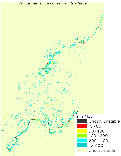
Grid: tanslope = tan(slopedeg div deg)
Grid: sinslope = sin(slopedeg div deg)
Grid: aobs = flux / sinslope
Grid: &s T = 65     /* transmissivity
Grid: &set depth 1    /* meter soil depth
Grid: &s phi 33     /* angle of friction
Grid: &s bd = 2.0   /* bulk density
Grid: &set coh 2 /* kPascals
Grid: &s tanphi [tan [angrad %phi%]]
Grid: &s low = [calc [calc [calc %bd% - 1] / %bd%] * %tanphi%]
Grid: wet1 = aobs / %T% / 1000
Grid: cossq = sqr(sinslope / tanslope)
Grid: qsat = %T% * 1000 / aobs
Grid: qnt%coh% = (1000 * %coh% /  ( 9807 * %depth% *  %tanphi% * cossq )  +  %bd%  * ( 1 - ( tanslope / %tanphi% )) ) * %T% * 1000 / aobs
Grid: qust%coh% = con(tanslope < %low%,9999,qsat < qnt%coh%,10000,qnt%coh% < 0,0,qnt%coh% > 9000,9000,qnt%coh%)
Grid: kill qnt%coh% all
Grid: qust%coh%c = reclass (qust%coh%,/jo3/www/stability/unstord.reclass)
Download the American-made flux grid. This unzips to a directory named usa containing one grid. Zipped size is 26996379 bytes.