About this table
about clipping collars and new rectangles
about tfw files
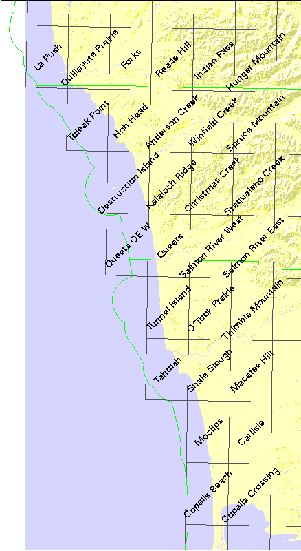
documentation from the USGS CDROM
| USGS name | # quads | DNR# | name | file size |
|---|---|---|---|---|
| c46124a1 | 35 | - | (Copalis and Cape Disappointment) | 4717978 |
| f47124a1 | 10 | - | COPALIS BEACH (SE quarter) | 7820910 |
| f47124e1 | 18 | - | FORKS (NE quarter) | 8312030 |
| z47124 | 28 | - | (Mosaicked 24K quads) | 70963833 |
| o47124h6 | 1 | 903 | La Push | 3225855 |
| o47124h5 | 1 | 904 | Quillayute Prairie | 1825387 |
| o47124h4 | 1 | 905 | Forks | 1603215 |
| o47124h3 | 1 | 906 | Reade Hill | 1988031 |
| o47124h2 | 1 | 907 | Indian Pass | 2721165 |
| o47124h1 | 1 | 908 | Hunger Mountain | 2939757 |
| o47124g5 | 1 | 1004 | Toleak Point | 3254545 |
| o47124g4 | 1 | 1005 | Hoh Head | 2745575 |
| o47124g3 | 1 | 1006 | Anderson Creek | 1467021 |
| o47124g2 | 1 | 1007 | Winfield Creek | 2198455 |
| o47124g1 | 1 | 1008 | Spruce Mountain | 2706762 |
| o47124f4 | 1 | 1105 | Destruction Island | 3147304 |
| o47124f3 | 1 | 1106 | Kalaloch Ridge | 1749909 |
| o47124f2 | 1 | 1107 | Christmas Creek | 2351209 |
| o47124f1 | 1 | 1108 | Stequaleho Creek | 2646814 |
| o47124e3 | 1 | 1206 | Queets | 2194717 |
| o47124e2 | 1 | 1207 | Salmon River West | 1540533 |
| o47124e1 | 1 | 1208 | Salmon River East | 1883050 |
| o47124d3 | 1 | 1306 | Tunnel Island | 2912069 |
| o47124d2 | 1 | 1307 | O'Took Prairie | 2014051 |
| o47124d1 | 1 | 1308 | Thimble Mountain | 1719683 |
| o47124c3 | 1 | 1406 | Taholah | 3192753 |
| o47124c2 | 1 | 1407 | Shale Slough | 2045939 |
| o47124c1 | 1 | 1408 | Macafee Hill | 1256076 |
| o47124b2 | 1 | 1507 | Moclips | 2389434 |
| o47124b1 | 1 | 1508 | Carlisle | 1088597 |
| o47124a2 | 1 | 1607 | Copalis Beach | 3782940 |
| o47124a1 | 1 | 1608 | Copalis Crossing | 2905549 |