
So how does this differ from < broken link > Dave and Bill's slope stability package < /broken link > ?
Thoughts on September 2, 2020: The physics is still good, but the software
is dated. (Though we just just updated an old windows executable below.)
Take a look at the python version
Arc:
prompt, and ends at the Grid: prompt. It makes a system call
to a C program sloparea.
The optional second argument can be the name of a mask grid or either of the
keywords grid or mouth. If a grid name is given,
the output stability grids will be masked to this grid. If the keyword
grid is given, the macro assumes that a cover named
boundary exists in the current or parent directory, and creates
a grid named shedg from it. If the keyword mouth is
given, the macro assumes that a grid named mouth exists,
containing a or more cells to define the watershed outlet. After sinks are
filled, a watershed boundary grid (named shedg) will be created.
You may use a # sign if you want to skip this argument and enter others.
The optional third argument is the name of a directory which contains the
cohord.reclass and unstord.reclass files. The
default location ./ is the current directory.
The optional fourth argument is the xscale. If it is omitted, it wil default to one, unless the grid projection indicates feet, in which case it will be .3048
The optional fifth argument is the zscale. If it is omitted, it wil default to one, unless the grid projection indicates feet, in which case it will be 0.3048 Use 0.1 if you have decimeters.
sloped. It is an integer grid
with a Z-scale which will make the max value close to the maximum
4-byte integer. The macro will tell you what this scale is.
The C program sloparea reads the exported version of the
filled DEM.
first determines the pour points of flat spots and increments elevations by
one unit so that no flat spots remain. The result is written out to the file
filledsloped.bil. The macro creates hdr and blw files so that
the bil file can be imported to ARC/INFO as the grid sloped.
sloparea continues to run, calculating flow
accumulation per unit length. It starts at the peaks and, through many
iterations, it assigns flows to all lower cells, proportional to the slope
(using a longer baseline on the diagonals) to each neighboring cell. It also
tracks the flux at every cell, dividing the incoming flow either by the edge.
The result is written out to the
file filledcum.bil. This is imported to ARCINFO as the grid flux.
slopedeg (slope in degrees), tanslope, and
sinslope. We also create aobs: flux / sin.
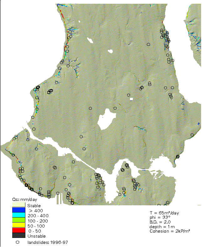
stability.aml sets the parameters
transmissivity, soil depth, phi, bulk density, cohesion, and the steady-state
rainfall assumed in critical cohesion. These can be easily changed, but the
user should be careful to keep track of all parameters expressed in the
output grids.
wet1 (wetness at Q = 1 mm/day)
and cossq (cos˛). Next it calculates rainfall-for-instability
for a cohesion of 2. It first creates an intermediate file qnt2.
Then it creates qust2, the actual Q value in mm/day, except that
cells to flat to fail are coded as 9999, cells that are stepper but are
still stable when saturated are coded 10000, and values greater than 90000 are
truncated to 90000.
Finally it creates qustc2c,
breaking the values into classes numbered 1-7 as defined in the
file unstord.reclass. It repeats this process for cohesion
values of 4 and 8. Next it calculates the value of Q for saturation
qsat), and breaks it into categories (qustc).
Finally, it recreates the classic analysis: phi = 45° and cohesion = 0
as grids qust45 and qust45c.
4/10/97: We now declare an area stable if rain-for-saturation is greater than rain-for-instability. These get a unique code is the qust%coh% grid, but are classified the same as low slopes in qust%coh%c.
5/8/97: Similar fix for critical rainfall.
8/11/98: Stability.aml automatically uses a correction factor if the horizontal units are feet.
10/15/98: new verion of sloparea. (See internal docs.)
7/1/2004: modified stability.aml so that it does not require unix or fortran, though it still calls sloparea. It should handle varied XY and Z units, floating-point grids, and long flat spots. (See internal documentation.) Sloparea was modified so that is will use the scaling factor with 4-byte DEMs.
1/27/2015: Even as Harvey is making excuses for not finishing a python rewrite (and as others are praising the SAGA version), he has updated stability.aml. It now scales up any DEM to the widest possible range of 32-bit integer values.
Direct questions to Harvey Greenberg and Dave Montgomery. Please send us a note if you use the model.
Main Geomorphology Research Group Page